ROUTING
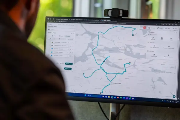
With Geposit Routing, you can easily plan optimal routes and calculate travel times, distances, and reachable areas.
SIMPLER AND SMARTER ROUTE PLANNING
Do you work with sales, service, or deliveries in the field? Then you often need to know the travel distances and plan efficient routes to ensure operational efficienty. Routing is our new service which siplifies route planning and analysis and calculations of reachable geographical areas.
Routing is available as an add-on module to our mapping service, Atlas, or as a standalone tool via API.
- Calculate travel times and distances between various locations, such as addresses or coordinates
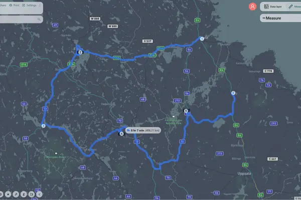
- Perform multi-stop calculations and plan optimal transportation sequences between multiple points
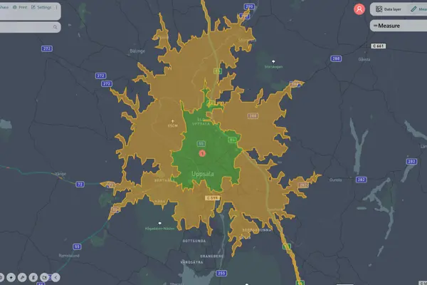
- Analyze reachable areas, identifying geographical areas accessible within a given time
- Customize calculations based on different vehicle types and configurations

CALCULATE DISTANCE AND TRAVEL TIME
Routing allows you to easily calculate routes and distances between different locations, as well as the time required for the journey. You can use coordinates, addresses, or other points of interest as your start and end points. Routing then determines the fastest possible way to reach your destination. You’ll receive alternative route suggestions and clear turn-by-turn directions to your next stop.
You can perform calculations for cars, trucks, bicycles, or walking. All calculations take the selected vehicle type into account. Additionally, you can configure advanced vehicle settings, such as specifying whether you are driving a light or heavy truck.
OPTIMAL ROUTES
How can you drive as efficiently as possible between multiple locations? Do you have recurring routes that you frequently travel? Many businesses rely on open mapping services to plan their routes, but these often come with limitations.
Routing is built on Geposit’s platform, using the most accurate and up-to-date reference data for addresses, postal codes, and geodata in the Nordics. The service allows you to easily plan optimal routes between multiple points. Simply set a starting point, define your stops along the way, and select your endpoint - Routing then automatically calculates the most efficient order for your journey.
You can also add scheduled breaks at different stops, such as rest and unloading time, and configure advanced settings for different vehicle types.


REACHABLE AREAS
How far can you reach within a given time? What is a reasonable area for a salesperson to cover?
With Routing, you can easily analyze your reachable areas - the geographical areas you can access within a specific driving time. Simply select a starting point, and you’ll quickly see how far you can reach within, for example, 10, 20, or 30 minutes of driving.
Routing works seamlessly as a complement to our mapping service, Atlas, allowing you to create more realistic zones, district divisions, and coverage areas. When using Routing as an add-on service to Atlas, you can choose to save the reachable area as it is or, for example, store the five-digit postal code areas "touched by" your reach area.
ADVANCED CONFIGURATIONS
Do you use cars, trucks, or bicycles for your transportation and deliveries? Or do you travel on foot while working in the field? With Routing, you can not only select your mode of transport but also configure advanced settings for each vehicle type.
Routing allows you to easily adjust settings based on your vehicle fleet. If you use multiple vehicle types, you can save predefined vehicle profiles for quick and easy reuse. Once your settings are in place, Routing calculates routes, travel paths, and reachable areas while taking your vehicle specifications into account.
👉 See examples of configurable parameters on this page.
|
|
|
|
|
|
|
|
|
WHAT DO OUR PILOT CUSTOMERS SAY?
"I am very positive about the tool. It is user-friendly and offers many features that simplify our planning process. We get a clear overview of which vehicle is best suited for different delivery areas, and it also allows us to easily optimize routes for our fixed delivery zones.
Our collaboration with Geposit has been excellent. They have been very receptive to our feedback and have always provided professional support, which has been invaluable to us.
We look forward to continuing to use this tool and benefiting from its many advantages in the future."
Johan Söderberg
Quality & Process Developer, CityMail


BUILT ON HIGH-QUALITY DATA
There are several other services on the market for route planning and navigation. What makes Geposit Routing unique is that it is built on our platform with the most accurate and up-to-date reference data for addresses, postal codes, and geodata in the Nordics.
We collect and process data from reliable primary sources and use advanced methods to keep it accurate and up to date. This enables us to continuously improve our digital services for address validation, giving you access to constantly updated address data.
PLANS & PRICING
SMALL
12 month subscriptipon
Access to API calls
Compatible with Geposit Atlas
Calculate travel distance and time between two points
Analyze and create reachable areas
495 SEK/MONTH
MEDIUM
12 month subscription
Access to additional API calls
Compatible with Geposit Atlas
Calculate travel distance and travel time between two or multiple points*
Analyze and create reachable areas
Optimize route planning between multiple points (multi-stop calculation)
Access to advanced transport and vehicle configurations
995 SEK/MONTH
LARGE
12 month subscription
Access to even more API calls
Compatible with Geposit Atlas
Calculate travel distance and travel time between two or multiple points*
Analyze and create reachable areas
Optimize route planning between multiple points (multi-stop calculation)
Access to advanced transport and vehicle configurations
1495 SEK/MONTH
*Maximum 100 points. Custom solutions are possible, please contact us for more information.